Skip to content

la croix de gattigues

GPS track database, South-Central France

  • Home
  • Track Database
  • Source documents
  • Posts
    • Heritage
    • Tech
    • Trails
    • Cartography
    • Topo Guides
  • Posts Index
  • EnglishEnglish
  • FrançaisFrançais

Tag: altitudes

Posted on February 27, 2017April 11, 2018

A bad day for measurements

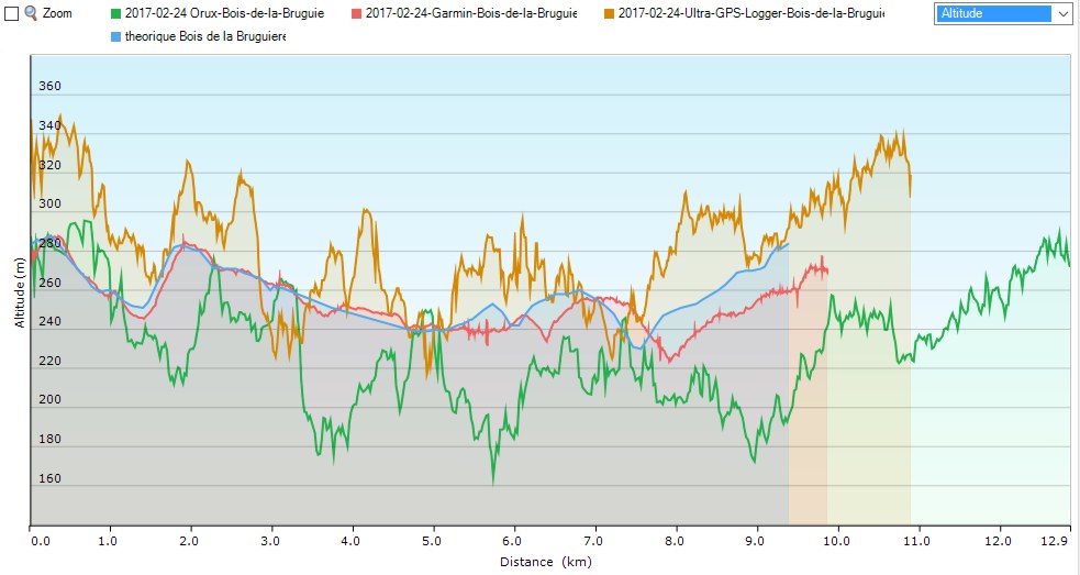
Here are the results of another try at comparing GPS track logs – in particular the elevation profiles – between different devices and applications.

elevation profiles
elevation profiles

The weather was fine, if a bit cold with gusty winds. The hike was mostly in open terrain or on wide forest tracks. Less than an estimated 20 % of the track was under forest cover. The devices and apps are : Continue reading “A bad day for measurements”

Hiking in south central France

This site is about walking, mostly in south central France,  specifically the Cévennes “mountain” range, the Grands Causses area with it’s plateaus and canyons, the departments of Gard with the garrigue landscapes, the Vaucluse, the Herault, sometimes the Ardèche, the Avéyron and the Drôme. There are descriptions of interesting walks, but sometimes also the non-interesting ones. There are occasional articles about the hardware and software you might use while hiking and in particular handheld GPS devices and smartphones. There are also references to cartography both in the field and on the computer screen back home. The progress in the area of web mapping in the past several years, with the arrival of services like Google Maps, Nokia Here (now “Here we go”) and the OSM Open source map service, has been spectacular.

However, hiking in this region is more than just walking with eyes focused forward or concentration on the GPS screen. It’s also about observing and understanding the landscapes, villages, farms, ancient ruins and various geological curiosities. Often the subject of interest is not the “what”, but the “why”. Why did people settle here hundreds of years ago? Why did the ancient trade routes pass this spot?

In this region, traces of human activity are everywhere – in the still occupied villages and farms, but also in the undergrowth, on the riverbanks and and on the abandoned hillsides. This site aims to explore these subjects, traveling on foot, at about 3.5 km per hour.

This site is also for people who like maps. There are maps in nearly every article, often with interactive features. Try them out.

For every walk mentioned in an article, the site provides a downloadable gpx file suitable for use on a handheld gps device. The site provides additional access to a database of some 500 circuits also complete with downloadable gpx. It is worth noting however, that a gpx track is a perishable commodity. Over time waymakings change, land owners block walking routes, obstacles appear. For this reason, when available, dates of the most recent passage on the circuits are also provided. Use with care.

Everywhere you go on these hiking routes you are likely to see a field cross.  They can be in iron, stone, or wood and can be simple or ornate. These field crosses are supposed to have protected travellers from bandits – as supposedly no bandit would dare attack near a symbol of the all powerful religion.

So the french word “croix” translates to cross and holds the connotation of the cross as a religious symbol. However, in the context of this site,  cross means crossroad or intersection. “La Croix de Gattigues” refers to a crossroad in a hamlet in the Gard department at which, no surprise, there is also a fine an iron cross.
South central France

Recent Posts

  • The Rouveyrac trail December 13, 2022
  • Mapping software update February 9, 2022
  • Abandoned rail lines in the Uzège district November 11, 2021
  • Vineyards and Camisards November 7, 2021
  • Happiness Lost November 4, 2021
  • Orchids in June October 30, 2021
  • PNC hiking data online October 30, 2021
Cookies and privacy policy

Meta

  • Log in
  • Entries feed
  • Comments feed
  • WordPress.org

© J. Cluchey, 2021

We are using cookies to give you the best experience on our website. You can find out more about which cookies we are using or switch them off in settings.

Powered by  GDPR Cookie Compliance
Privacy Overview

This website uses cookies so that we can provide you with the best user experience possible. Cookie information is stored in your browser and performs functions such as recognising you when you return to our website and helping our team to understand which sections of the website you find most interesting and useful.

You can adjust cookie settings by navigating the tabs on the left hand side.

Strictly Necessary Cookies

Strictly Necessary Cookies must be enabled at all times to permit the site to function properly.

These cookies include a cookie to record your language preference, cookies to permit the use of Google maps programming interfaces and maps, and cookies to permit the use of OpenStreetMap maps on this site.

If you disable these cookies, we will not be able to remember your language preferences.

3rd Party Cookies

This website uses the Matomo web analytics platform to measure site activity. Matomo places cookies in your browser to collect information such as visitor language, device type, time and duration of visit, pages viewed, downloads etc. None of this data can identify you personally. The collected data is retained on a server located in France, owned and operated by the owner of this website. The collected data is not used for advertising and is not shared with third parties.

Please enable Strictly Necessary Cookies first so that we can save your preferences!

Cookie Policy

More information about our Cookie Policy